

Architectural drawings
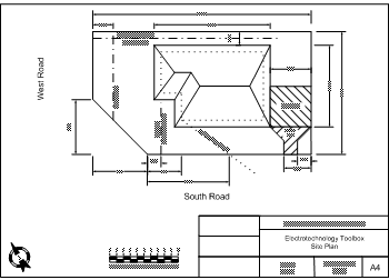
Site plan
The site plan shows a new or existing building's position in relation to the boundaries of the block of land. Information usually on the plan includes:
- dimensions of the block boundaries
- exterior dimensions of the building (walls and eaves)
- dimensions of the building from block boundaries
- orientation to north
- property lot number and plan number
- street/road name
- easements
- scale of the plan
- contours of the block
- position of services (underground power, water, sewer, etc)
- driveways
- position of other structures on the site.
Any or all of this information may be required when a job is to be carried out at a site, eg you may need to lay underground conduit between two new buildings before concrete flooring is laid. You would need to refer to the site plan to determine location of the switch board, building positions, overlapping services or driveways, etc.
An example site plan is shown below.
Select the image to view at full size (Word 308kb)
Site plan